Bicycling along the Revolutionary Trail Scenic Byway
View Bicycle the Revolutionary Trail Scenic Byway in a larger map Click to refresh the map
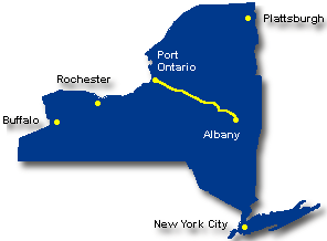
![]() Running just below the Adirondack Park, the Revolutionary Trail covers an area steeped in military history. The tour begins in Albany and continues west along the Mohawk River for 158 miles to Port Ontario on Lake Ontario. See the Mohawk Valley Heritage Corridor for more information on this Byway.
Running just below the Adirondack Park, the Revolutionary Trail covers an area steeped in military history. The tour begins in Albany and continues west along the Mohawk River for 158 miles to Port Ontario on Lake Ontario. See the Mohawk Valley Heritage Corridor for more information on this Byway.
The Mohawk River follows an ancient pathway connecting two prehistoric lakes. Created by glaciers and carved out by melting ice water, this valley once drained the entire Great Lakes region. The western counties, Oneida and Herkimer, form the edge of the glacial lake Iroquois that then covered all of western New York. In Fulton and Montgomery counties, the river valley runs between parallel ridges of rock rising to the Adirondacks in the north, and up through Schoharie County into the Catskills to the south. Further east the river flows through the broad valley created by glacial Lake Albany – today Schenectady, Saratoga and Albany counties – and into the Hudson River.
As the only water level route through the Appalachian Mountain chain, the Mohawk River Valley has been an important transportation corridor for centuries. This is the homeland of the Mohawk and Oneida nations of the Haudenosaunee, also known as the Iroquois Confederacy. They first controlled this strategic gateway to the west, putting them at the center of European battles to control the North American continent. Pivotal battles of the American Revolution for Independence were fought at both ends of the valley: in the successful defense of Fort Stanwix, the bloody massacre at Oriskany, and British General Burgoyne’s surrender in the Battles of Saratoga.
This geography has shaped the history of New York State. The Erie Canal was first completed in the Mohawk Valley. It pushed the American nation westward, spreading the Industrial Revolution along its route. Immigrants and ideas easily flowed back and forth among the communities and states that it connected, nourishing many of America’s technological innovations and social movements. After the Erie Canal – and following those same Native American paths through the center of the Mohawk Valley – were developed the New York Central Railroad, early highways, the New York State Thruway (I-90), and the State Barge Canal.
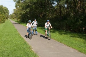
Family Bike Rides
Along much of the Revolutionary Trail is the New York State Canalway Trail System, comprised of a network of more than 260 miles of existing multi-use, recreational trails across upstate New York, with the potential to double that along the 500-mile route of the Erie Canal. The Canalway Trail System is comprised of four major segments: the 100-mile Erie Canal Heritage Trail in Western New York; the 36-mile Old Erie Canal State Park Trail in Central New York; the 60-mile Mohawk-Hudson Bikeway in the eastern Capital Region; and the eight-mile Glens Falls Feeder Canal Heritage Trail in the foothills of the Adirondacks near Lake George. In addition, there are smaller segments of Canalway Trail.
Cycling Along the Canals of New York State (Rossi) is a great guide to this and other canal areas in NY.
Some of the possible family rides include:
- Mohawk-Hudson Bike-Hike Trail – This 40-mile paved path is almost continuous except for a few gaps where the route is on-road. The west end of the pathway is in Pattersonville west of Albany and it follows the Mohawk River east to where it meets the Hudson River, then follows the Hudson south between the river and the city of Albany, to Erastus Corning Riverfront Preserve. also see Schenectady County
- Cresent Trail-Erie Canal Trail, Halfmoon – There are about 2.5 miles of dirt path along the north bank of the Mohawk River in the Crescent Park area of Halfmoon. It starts right near the Route 9 bridge crossing where there is a small parking area near the junction of Vischer Ferry Road and Old Canal Road. It heads west from there, and the town has plans to add another 2.5 miles that will pass under the Twin Bridges and meet up with a section of path in Clifton Park.
- The FJ&G Rail Trail, Gloversville & Johnstown – An abandoned railroad bed is home to Fulton County’s 8-mile Rail Trail. This paved, landscaped trail is a pleasure for many forms of recreation including bicycling, jogging, rollerblading, and cross-country skiing. The Rail Trail is accessible to the public in many locations, at least 4 parking areas are designated, and the trail is handicapped accessible. Plans are to develop another 20 miles of Rail Trail. Contact Fulton County Tourism in Gloversville for more information.
- The Fultonville 10-mile Bike Path Ride on the Canalway Trail is a 10-mile, one-way ride on a paved section of path going west from Fultonville.
- The Rome-Oriskany 6-mile trail segment that is near the Oriskany Battlefield State Historic Site goes through the Oriskany Flatts State Wildlife Management Area. Parking is available at the intersection of Routes 69 and 365 and on River Street between Routes 49 and 69. See the pdf listing Bicycling Paths and Multi-Use Trails provided by Herkimer and Oneida counties.
Road Bike Opportunities
Road bike possibilities include:
- Rexford Ramble Historic Bike Tour, Vischer Ferry and Rexford – Cyclists follow a 15-mile self-guided tour of historic western Clifton Park that locals call the Rexford Ramble. Starting and finishing at the Vischer Ferry Fire House, this ride was designed for a National Trails Day celebration in Clifton Park and is best enjoyed on a weekend morning or mid-morning on a week day, when traffic is light. Download the map and narrative of this and other rides from the website of the Mohawk Towpath Byway.
- The Syracuse-Rome 36-mile trail segment along the Old Erie Canal towpath, passes through the Old Erie Canal State Park between State Bridge and Rome. There are on-road links using Canal Street between Durhamville and State Bridge and Lock Road in the vicinity of Lock 21 near Stacy Basin. Parking is available at a rest area east of State Bridge on Route 46, at Lock 21, and at the Erie Canal Village on Rome-New London Road (Route 46). Use caution and walk your bike carefully when traversing the downstream gate at Lock 21. See the pdf describing these and other “Bicycling Paths and Multi-Use Trails” featured in the Herkimer and Oneida Counties Bicycling Atlas.
- Rome to Sylvan Beach, a 40-mile round-trip ride mostly along lightly traveled roads, with Verona Beach State Park as the refreshing destination. Another version of the ride can be done as a 45-mile loop through Oneida. A 76-mile loop from Rome follows the south shore of Oneida Lake and takes in Bridgeport, Manlius, Chittenango and Canastota. NYS Bike Route 5 & 69 passes through Rome on its route across the state from Niagara Falls to Albany.
- The Seaway Trail Salmon Hatchery Bicycle Loop is a 23-mile loop that features a ride along the Salmon River that crosses the river in two locations. The Salmon River State Fish Hatchery at Altmar features exhibits and displays of the hatchery’s work. There is some climbing on this ride up and over the shoulder of the wooded Tug Hill Plateau. The highest point is 500 feet higher than Lake Ontario, but the views are worth the ride. The roads on the Salmon Hatchery Loop are mostly quiet blacktops with a few busy stretches. Avoid State Rt 13 in the vicinity of Pulaski and use County Rt 5 instead to get back on the Great Lakes Seaway Trail.
State Bicycle Route 5 is on or near a portion of the Revolutionary Trail. The New York State Department of Transportation (NYSDOT) developed this and other statewide routes to assist experienced cyclists in planning long-distance bicycle trips. There are maps, mileage charts, and service summaries posted online at Bicycling in New York State.
Lou Rossi mentions NY State Route 5 in his informative guide, Cycling Along the Canals of New York State:
The Mohawk Valley is a great place to bicycle and the forty miles across Montgomery County offers some great options. The Canalway Trail (paved and unpaved) is almost complete for off-road riding. Bike “5″, along NY 5 S, is directly adjacent offering a continuous, parallel on-road route. And NY 5, on the Mohawk River’s north shore, provides a cycling alternative all along the way. Loops are very easy to find – there are sixteen bridges across the Mohawk River from Schenectady to Utica and all are bicycle-friendly. Not only is there easy riding in Montgomery County, but along with some great Erie Canal history to see, the area is host to many Mohawk Indian and colonial and Revolutionary War sites. (p. 60 – 2nd Edition, 2006)
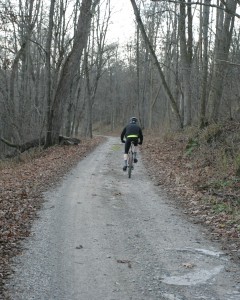
Mountain Biking
Mountain biking possibilities include:
- BREIA Trail System – Near Boonville and Alder Creek, the Black River Environmental Improvement Association (BREIA) offers more than 50 kilometers of trails in three diverse landscapes, each providing a distinctive biking experience. Promoted mainly as cross-country ski trails, mountain biking is permitted on most trail sections, with a few exceptions. Maps for each system are available at the trailheads.
- Boonville-Pixley Falls Black River Canal Trail – A seven-mile rolling grass trail connecting Boonville and beautiful Pixley Falls State Park, part of the BREIA Trail System. Maps available from BREIA and from the Herkimer-Oneida Bicycle Atlas.
- Old Erie Canal State Park – a 36-mile stretch of the 363-mile Old Erie Canal with a terminus in Rome. Designated a National Recreational Trail by the National Parks Service, the terrain is woodland and wetland, offering pleasant biking opportunities for families on a short ride or for distance riders that want a reprieve from highway riding. Historic sites include remnants of stone aqueducts.
- There is some great fat-tire family riding at Great Bear Springs, between Fulton and Phoenix off County Rt. 57. It is a 236-acre area owned by the City of Fulton and the Town of Volney Park, and managed in part by a volunteer group – the Friends of Great Bear. There are seven different trails totaling about 8 miles. Great Bear Springs has been a source of spring water for over 200 years and was bottled for sale starting in 1885, and the ruins of several former wells and pump houses remain. The property also contains the historical Hinsmanville Lock and towpath that were a part of the original Oswego River Canal, one of 18 locks between the Erie Canal in Syracuse and Lake Ontario. Recreational use of Great Bear Springs can be traced back to the 1930’s when the Civilian Conservation Corps planted the softwood forest.
- Check out the Winona State Forest trail system, east of Mannsville. It provides a large network of 70 miles of roads and trails, promoted mainly for winter use. Mountain bike use of the area seems to be growing and the cross-country ski map is a good place to start exploring the area’s mountain biking opportunities.
see more info on Erie Canal State Historic Park
Not to Miss
- Waterford Harbor Visitor Center
- Peebles Island State Park
- Cohoes Falls on the Mohawk River
- Harmony Mills Historic District
- FJ&G Rail Trail, Gloversville & Johnstown
- Canalway Trail
- Johnson Hall State Historic Site
- The Kateri Tekakwitha Shrine
- Erie Canal Village
- Fort Stanwix
- Oriskany Battlefield State Historic Site
- Mexico Point State Park and Beach, a small secluded beach.
Bike Events in the Area
- Bike the Byway, Colonie, 2nd Saturday in August – A casual, 36-mile ride with historic interpretation at refreshment stops along the way. 9AM start at the entrance to Colonie Town Park on Schermerhorn Road (in 2011). Points of interest include river valley vistas, the confluence of the Mohawk and Hudson rivers, 19th-century Erie and Champlain Canal features, current-day canal facilities, Falls View Park in Cohoes, and Waterford’s harbor area. Ride shirt will be available for a donation of $20 or more to the Mohawk Towpath Scenic Byway Coalition.
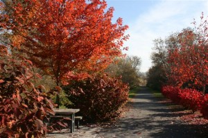
- Mohawk Towpath Byway Duathlon – Crescent and Vischer Ferry, the 3rd Sunday in October, when the foliage is at its peak. The 2.2-mile run, 16-mile bike, and another 2.2-mile run to the finish is a popular event along the Mohawk River and raises funds for the Mohawk Towpath Byway.
- Erie Canal Bike Tour
also see the complete list of bike events in the region
Bike Shops Nearby
- CK Cycles, Albany
- Down Tube Cyclery, Albany 518-434-1711
- Elevate Cycles II, Clifton Park
- Plaine & Son, Schnectady
- Freeman’s Bridge Sports, Scotia
- Adirondack Bicycles, Scotia 518-374-7989
- The Bike Works, Johnstown 518-762-1342
- Dick’s Wheel Shop, Herkimer
- Bikes & Boards at Surf N’ Ski, New Hartford 315-768-1190
- Dick Sonne’s Cycles Fitness & Skis, New Hartford
- Schuss Ski & Bike, New Hartford
- Guy’s Bicycle Shop, Madison
- Mike’s Cycle & Sport, Rome 315-337-1940
- Doyle’s Bike Shop, Fulton 315-592-4537
- Murdock’s Bicycles, Owsego
also see the complete list of bike shops in the region
Visitor Information
- Adirondack Regional Chamber of Commerce
- Albany County Convention and Visitors Bureau
- Fulton County Tourism
- Greater Utica Chamber of Commerce
- Hamilton County Visitor Information
- Herkimer County Tourism Information
- Montgomery County Tourism
- Oneida County Tourism Information
- Oswego County Biking & Hiking
- Rome Area Information
also see the complete list of visitor information resources for the region
Check in with Chamber offices, bike shops and other sports shops in the area to get the latest information and review your route with someone knowledgeable of the area. When biking, dress for the weather and carry water, snacks, map, repair kit and cell phone. When biking in rural areas, services could be few and far between, and cell phone service may not always be available. See the Before You Ride notices in the bottom section of this website, as well as the Disclaimer notice.
| Warren County Bikeway | Glens Falls | Lake George Village |


