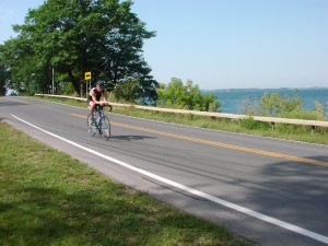
Biking along the Great Lakes Seaway Trail
View Great Lakes Seaway Trail Scenic Byway in a larger map refresh map
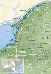
The Great Lakes Seaway Trail is one of America’s Byways and is recognized for its unique landscape, scenic freshwater coastline and historical significance. Its New York portion stretches 518 miles along a freshwater shoreline, including the St. Lawrence River, Lake Ontario, the Niagara Riverand Lake Erie. This Bike the Byways description features the eastern segment within northern New York, a beautiful 180-mile span between Massena on the St. Lawrence and Oswego on the shore of Lake Ontario. Communities along the way include Waddington, Ogdensburg, Morristown, Chippewa Bay, Alexandria Bay, Clayton, Cape Vincent, Dexter, Sackets Harbor, Henderson Harbor and Port Ontario. Travel themes include history, architecture, maritime heritage, lighthouses, agritourism, sportsfishing, the Gilded Age and more.
See the Great Lakes Seaway Trail website for all the details about this exciting National Scenic Byway, selected as one of America’s Byways by the U.S. Department of Transportation. America’s Byways “possess outstanding qualities that exemplify the regional characteristics of our nation.” The Seaway Trail was chosen for its unique landscape, which has been sculpted by the forces of nature, and for its historical significance.
Community Connections along the Great Lakes Seaway Trail
A variety of bicycling opportunities – as well as suggestions on what to see and do – are highlighted in four segments along the Great Lakes Seaway Trail, starting in the east (click on the segments to view).
- Massena – Ogdensburg, 46 miles
- Ogdensburg – Clayton, 48 miles
- Clayton – Sackets Harbor, 41 miles
- Sackets Harbor – Oswego, 50 miles
Crossing the St. Lawrence River by Bicycle
If you are planning to cross the U.S.–Canada border by bike, bicyclists – as with all travelers – need to have a passport or an enhanced driver’s license, or the Sentri or Nexus identification cards.
On or near the Great Lakes Seaway Trail are three locations to cross the St. Lawrence River by bicycle (and one of them is NOT the Ogdensburg-Prescott International Bridge):
- Massena NY and Cornwall ON – Bicyclists may cross Seaway International Bridge at the Three Nations Crossing near Massena NY and Cornwall ON (RT 138 in Canada). There is no walkway on the bridge but the traffic lanes are wide, providing room for bicyclists to ride. Exercise extreme caution at several expansion joints, especially when riding down off the bridges. Headquartered in Canada at Cornwall, Ontario, 613-932-6601.
- Alexander Bay NY and Ivy Lea ON – Bicyclists may cross the Thousand Islands Bridge (I-81 in the U.S.) but bicycles must be walked – not ridden – on the bridge sidewalks. Headquartered in the U.S. at Alexandria Bay, 315-482-2501, info@tibridge.com.
- Cape Vincent NY and Kingston ON – This is an enjoyable crossing of the St. Lawrence for bicyclists because it involves two ferry rides and a bike ride across Wolfe Island, which offers great biking and is very popular among bicyclists on both sides of the border. A map of Wolfe Island bike route and ride suggestions is provided by the Wolfe Island Business and Tourism Association.
- From the US side, the ferry leaves from Cape Vincent to Wolfe Island. The Horne Ferry runs almost every hour between 8:00 am and 7:30 pm, from May 1 to mid-October. It costs $2.00 for bicyclists and the ride is less than 30 minutes. For more information: 315-783-0638 in the US.
- From Canada, the Wolfe Islander III ferry is in operation all year and operates from Kingston’s Marysville Dock in the summer. The ferry is free and runs each hour from 6:00 am to 1:00 am and the crossing time to Wolfe Island is 20 minutes. For information: 613-548-7227 in Ontario.
see additional information on ferry service to Wolfe Island.
The Ogdensburg-Prescott International Bridge does not allow for bicycle riders to cross on or with their bikes at this time. Walking or riding bikes on the bridge’s sidewalk had been allowed in the past but was prohibited by 2011, and there are plans to remove the sidewalk to widen the road.
The Border Madness website provides additional information on crossing the border by bicycle, although some sections appear out of date.
When biking in a rural area, services could be few and far between, and cell phone service may not always be available. See the Before You Ride notices in the bottom section of this website, as well as the Disclaimer notice.
Below are some of the sights along the way. Scroll over an image to see its title, or click an image to enlarge it and then move through the entire gallery (click on a large image to return here, rather than using the back-button).
[nggallery id=32]


